New images reveal true impact of freeways on Cleveland's neighborhoods
 Bob Perkoski
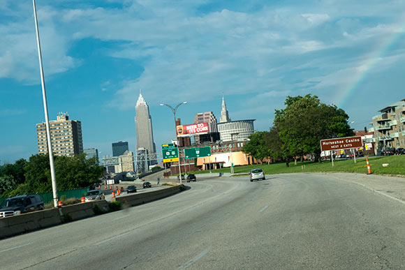
Here at Fresh Water, we write a great deal about Cleveland's neighborhoods and how they're constantly transforming. Hence, the following words from Tim Kovach caught our eye. In this essay, he pulls the camera back and gives the reader a wide-angle view of how freeways changed Northeast Ohio's landscape. While area freeways connected Cleveland proper with points across the county and beyond, the street-level impact on dense urban neighborhoods was profound and enduring.
Last month, Chris Olsen of Environmental Systems Research Institute (ESRI) uploaded some amazing aerial maps of Cleveland into its geographic information system, ArcGIS, which document the land use changes in the region over the past 65 years. As we all know, while Cuyahoga County's population declined from 1950 to the present, the remaining population has spread out throughout it and neighboring counties. As a result, whereas just 26 percent of the county's land was developed in 1948, this number exploded to 98 percent by 2002.
One of the major factors contributing to this trend was the development of the interstate highway system, which began after the passage of the Federal Aid Highway Act of 1956. Accordingly, the aerial maps from 1951 provide us with a snapshot in time just after the City of Cleveland's population reached its peak of 914,000 and just before the highway system helped usher in decades of population loss and decline.
Beyond just aiding the movement of people out of the city and into the suburbs and eventually exurbs, these images demonstrate the extent to which the Interstate Highway System devastated wide swathes of the city. Whole neighborhoods were torn apart as homes and businesses were demolished to make way for freeways. It would take decades for many of the neighborhoods carved up by these freeways, such as Tremont, to stem the associated decline. Other neighborhoods, such as Slavic Village and Clark-Fulton, have yet to rebound. The images below display what some of these areas looked like in 1951 and how these same areas look today, six decades later.
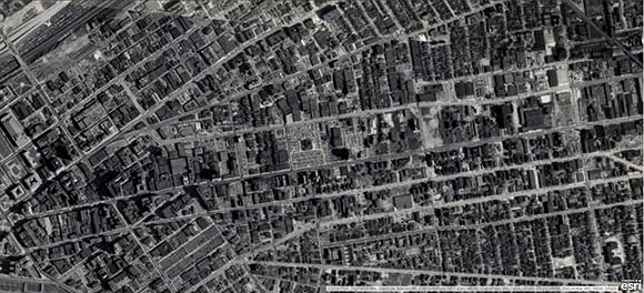
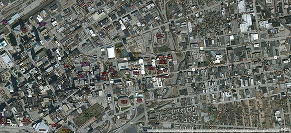
Gateway District (Downtown)
This image displays the southern reaches of downtown Cleveland, including the eastern end of the Lorain-Carnegie (Hope Memorial) Bridge and what is now known as the Gateway District. While this portion of downtown was densely developed through 1951, the construction of the Innerbelt beginning in 1954 radically altered the area. The replacement of the Innerbelt Bridge, which has since become functionally obsolete, is still ongoing.
 Gateway District (Downtown) 1951
 Gateway District (Downtown) 2015
Further reading: End the sprawl, improve air quality
Campus District (Downtown)
These images document the changes in the Campus District around Cleveland State University, which did not exist until 1964. It has taken over a significant portion of the eastern section of downtown in recent decades, but this area was also divided in two with the construction of Interstate 90.
 Campus District (Downtown) 1951
 Campus District (Downtown) 2015
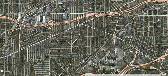
Slavic Village/East 55th Street (near east side)
Further east, we find the area around Cleveland's Industrial Flats and East 55th Street. This neighborhood has seen its fair share of ups and downs over the years. The railroad depot in the upper right-hand quadrant was formerly known as Kingsbury Run, wherein the infamous Cleveland Torso Murders of the 1930s played out. This same railyard is now the primary rail hub for the Greater Cleveland Regional Transit Authority. Ultimately, the images display the extent to which the construction of I-90 and, later, I-490, drove a massive wedge into this area. While the continuation of I-490 further east fortunately never materialized, the controversial Opportunity Corridor is essentially the reboot of this project.
 Slavic Village/East 55th Street 1951
 Slavic Village/East 55th Street 2015
Further reading: Exalting and nurturing the fragile Cuyahoga
Tremont/Industrial Flats (near west side)
Heading southwest across the Cuyahoga River, we find ourselves on the southern fringes of Tremont. Much like the areas around East 55th Street, Tremont has been broken into four sections by the junction of I-90/Innerbelt and I-490. This newly trendy, gentrified neighborhood had historically been home to low-income, blue-collar workers of various ethnic groups. When I-90 broke off the neighborhood from Ohio City, located just to its northwest, Tremont entered into a decades-long decline.
 Tremont/Industrial Flats1951
 Tremont/Industrial Flats 2015
Clark-Fulton/Stockyards (near west side)
Further southwest of Tremont is the Clark-Fulton and Stockyard neighborhoods. This area, too, has historically been home to blue-collar workers. The construction of I-71 and Ohio Route 176, which break apart in the upper right of the modern image (near the Alcoa plant) brought about the bulldozing of much of this neighborhood.
 Clark-Fulton/Stockyards 1951
 Clark-Fulton/Stockyards 2015
West Boulevard/Cudell (west side)
Lastly, this image shows the change in the West Boulevard/Cudell neighborhood, which has become notorious as the location where Cleveland police officer Timothy Loehmann shot 12-year-old Tamir Rice. But if you drive down West Boulevard or West 98th Street, you can see that, decades ago, this area was home to upper middle class Clevelanders. Today, I-90 leaves a massive scar through the middle of the area, making large portions of the surrounding surface streets such as Lorain Avenue, difficult to navigate on foot or bicycle.
 West Boulevard/Cudell 1951
 West Boulevard/Cudell 2015
Ultimately, these aerial images provide a striking juxtaposition of two Clevelands: one at its economic zenith, the other struggling to emerge from its nadir. While the Interstate Highway System provided a lot of benefits to the United States that aided its post-war economic growth, these images help us understand just how devastating that change was for cities like Cleveland.
Originally published at timkovach.com. Reprinted with permission. Kovach is an independent analyst and blogger from Cleveland who researches and writes about climate change, disaster risk reduction, and transportation here. His work has appeared on Grist, Vox, and Streetsblog.
Images Copyright: Environmental Systems Research Institute (ESRI)
The thoughts and opinions expressed herein do not necessarily reflect the views of Fresh Water Cleveland and its staff.